Salt lakes, deserts, monasteries, and high-altitude wilderness: discover Qinghai’s raw beauty on a road trip from Xining (西宁) to Yushu (玉树) across the Tibetan Plateau.

Qinghai (青海) is one of China’s largest and least explored provinces. Even tourists who are willing to discover more off-the-beaten-path areas, such as Western Sichuan (here’s my travel guide), rarely venture further west on the Qinghai-Tibet Plateau.
If you’ve been dreaming of a road trip that feels like driving across a lost planet with vast grasslands, high-altitude deserts, glowing salt lakes, and surreal rock formations, then this part of China might just be what you’re looking for.
The first time I travelled to Qinghai was a few years ago, on a mission to photograph the last Snow Leopards (you can read my story here), and I was completely amazed by the ruggedness of the area. It was one of my first trips in China, and I had no idea how wild it was.
This time, I went back for a road trip from Xining to Yushu, and honestly, it was one of the most unforgettable routes I’ve done in China. This guide breaks down the itinerary for you and can serve as inspiration if you want to travel to rarely visited areas.
But before we hit the road, let’s talk timing, planning, and whether to go solo or join a tour.
Best Time to Visit Qinghai

Choosing the right time of the year is the most important choice, since it will affect what you’ll be able to see. The best window to explore this region is from June to October. During these months, the grasslands are green, and most areas are accessible.
- June–July: Qilian is in bloom with wildflowers. This is peak season for photography.
- August: Still green, but higher chances of rain in some areas.
- September: Grasslands begin to turn golden, with fewer people and cooler temperatures.
- October: Beautiful but colder. Some mountain passes might get early snow and be closed.
- November to May: Too harsh unless you’re very experienced. Expect road closures, snow, and isolation. Not recommended as it can be dangerous (a few people do die every year).
- November to early March: Ideal only for wildlife photographers, especially for Snow Leopards (this agency arranges wildlife tours on the plateau).
I went in mid-July. It was perfect: crisp air, blue skies, and no crowds (except at the extremely popular Salt Lakes).
The main challenge of travelling in Qinghai

Before delving deeper into this guide, I want to be perfectly clear with you. Qinghai, in my personal experience, is the most challenging province for foreigners to travel to in China.
This might come as a surprise since people might think that Tibet or Xinjiang are the stricter areas, but this is only partially true.
Tibet is very strict, and only a few areas are open to foreigners, who must have a Tibetan guide with them at all times and obtain a special permit to enter Tibet. However, the rules are clear, and obtaining the permit is simply a matter of paying a travel company. There’s zero effort on your part. Once everything is ready, you can easily explore Tibet since the rules are clear.
Xinjiang is surprisingly easy to explore, and you won’t need any permits except for a few areas that are clearly marked.
The real challenge is Qinghai, as the areas forbidden to foreigners are constantly changing, sometimes monthly and even weekly (which is why I won’t include a list; it will likely be outdated within a month). And even then, you are essentially left at the mercy of the local police, who have the power to refuse you entry to areas that are technically open, and there’s nothing you can do about it; this happened to me.
Additionally, it’s still very common to be refused by hotels, which claim they don’t have the permit to host foreigners: this is a lie, as I explained here. However, unless you want to start an endless fight that takes hours and involves the police, it is better to try a different hotel.
Other areas are open but require a special permit to cross (for example, Kekexili), and it can take some time to determine where and how to obtain it. We had to visit three different police stations at 10:00 pm and make endless phone calls before we found one willing to simply print a piece of paper that allowed us to drive through that area the following morning. No one wants to take responsibility.
I’m not telling you this to discourage you from visiting Qinghai. For these very reasons, you’ll find very few Western tourists. I just want you to be prepared.
DIY vs. Travel Agency

You have two options for exploring Qinghai: drive by yourself or book a tour with a driver.
Many people ask me about public transportation options for similar trips. Well, there’s no public transportation to most of the places mentioned in this article, and even if there were, it would miss the whole point of the trip: the freedom to stop whenever you want to take photos or just enjoy the scenery.
I travelled with this company, and it was my fourth trip with them. I highly recommend this agency, as they specialise in remote areas across the Tibetan Plateau. If you are interested in a trip, mention that Fabio sent you, and you’ll receive a small discount.
If you want to drive by yourself (a valid option if you speak Chinese), you’ll need a Chinese driver’s license or an officially translated and certified version of your foreign license. Send me a DM on Instagram, and I’ll tell you how you can do it.
A private driver will add peace of mind, especially in case of altitude sickness or car trouble, which is not uncommon. Most importantly, the agency will resolve all issues related to obtaining permits to access areas with tighter controls for foreigners.
If you are travelling independently, I recommend using Trip to book your accommodation in advance, especially in remote areas, as there may be limited options available.
Itinerary from Xining to Yushu
This is approximately the itinerary I followed; you can use it as a guide and source of inspiration. If you are not interested in some of the places I visited, just skip them and go to the next destination.
Xining (西宁), Qinghai vibrant capital

Historically an important stop on the ancient Silk Road, Xining today blends Han, Tibetan, Hui, and other ethnic cultures. I recommend spending one night there. Two nights are probably a bit too much.
The city has quite an interesting mix of Islamic and Tibetan cultures that seem to “coexist peacefully”, since, as our taxi driver admitted, “You are not allowed to say that you don’t like each other.“
The two main mosques are Dongguan (东关清真寺) and Nanguan (南关清真寺), and both have been “harmonised” recently to better fit Chinese architecture (no Crescent).


There are also a few beautiful night markets where you can try some unique street food that blends East and West Chinese cuisine. The most famous one is Daxinjie (大新街夜市), and I recommend visiting it after 20:00.
The Salt Lakes

Qinghai is home to some of China’s most stunning salt lakes. Unfortunately, the less touristy ones are off-limits to foreigners. So at the moment of writing this guide, you can only visit three: Qinghai Lake, Chaka Lake, and Chaerhan Lake.
Qinghai Lake (青海湖)

Surrounded by rolling grasslands, snow-capped mountains, and fields of blooming rapeseed in the summer, Qinghai Lake (青海湖) holds significant cultural and ecological value, particularly for the Tibetan and Mongolian communities. It’s a major stop for migratory birds and is protected as part of a national nature reserve. With its 4,400 square kilometers, it’s the largest lake in China. To put that into perspective, it’s roughly six times the size of New York City.
Qinghai Lake is a saline lake, but it’s not a salt lake in the traditional sense, as it is not used for mining solid salt. It contains saltwater, but it’s relatively low in salinity compared to true salt lakes. Although it’s technically a saltwater lake, it’s not commercially exploited for salt extraction, unlike the others.
Since this place is easily accessible from Xining, it can get quite crowded. The north shore (青海湖断崖) is a bit less touristy than the south one.
Chaka Lake (茶卡盐湖)

Chaka Lake (茶卡盐湖), also hilariously called Caka Lake, is a smaller but really pretty salt lake known for its mirror-like surface that reflects the sky, earning it the nickname “Mirror of the Sky in China.” The lake has been mined for salt for over a thousand years, and traditional salt harvesting methods are still in use.
Unfortunately, it’s also super touristy, and you’ll find a lot of people. There is a small, slow train that takes you a few km into the lake, and then you can walk in the water. This is good because it means that you can find a spot without people to relax and take some pictures.
In this lake and the next, I truly recommend using a drone if you are a photographer. The first picture of the article was taken in this lake, and if you don’t have a drone, you’ll miss out. Don’t forget to register it before heading to China. You can use this drone registration service if needed.
Chaerhan Lake (察尔汗盐湖)


Chaerhan Salt Lake, also called Qarhan or Cha’erhan, is the largest salt lake in China and one of the world’s largest salt flats, occupying approximately 5,856 km². The lake holds an estimated 60 billion tonnes of salt resources, enough to feed the world for millennia, making it China’s most important base for salt production.
This lake is incredibly spectacular when viewed from a drone, but if you don’t have one, it can be a bit underwhelming. There are a lot of tourists, and until the huge panoramic wheel is completed, there’s no way to get a bird’s-eye view of the area.
What makes this place unique is the green color of the water, caused by a combination of high salinity, mineral content, and algae. The landscape looks absolutely alien.
As with the case of Chaka Lake, don’t expect to be alone: the area is quite touristy, as it’s also easily accessible from Xining.
Golmud (格尔木), Kunlun Mountains (昆仑山) and Hoh Xil (可可西里)

This is where the itinerary becomes otherworldly. Golmud is the starting point for one of the most beautiful roads in the world, which crosses the imposing Kunlun Mountain Range.
Golmud is also the last city until you complete this part of the route. So don’t forget to get supplies and some oxygen in case you might need it due to the high elevation: part of the road is above 4700m, and the headache can hit you pretty hard.
This mountain separates the arid deserts of Central Asia from the high-altitude Tibetan Plateau, playing a crucial role in the climatic and geographic division between Inner Asia and the Tibetan cultural regions. The mountain range is also extremely important in Chinese mythology, as it’s often regarded as the center of the world, the home of the gods, and a paradise realm.
As you drive from Golmud to Budongquan (不冻泉), you’ll see the landscape slowly changing from sand dunes to high plateau grassland. But the second part of the road, in the Hoh Xil, also called Kekexili, is absolutely stunning. This is considered one if not the least densely populated areas in the world.
The high plateau is incredibly rich in wildlife, and you’ll see a lot of wild animals, ranging from Wild Donkeys to Tibetan Gazelles (Goa), and, with a bit of luck, rare Wild Yaks and Tibetan Antelopes.


This is a side of China that few people get to see and is totally worth the effort of getting there. The animals are very well protected, and some areas have recently been completely closed off to humans.
Besides the wildlife, you’ll see incredibly beautiful landscapes that very few Chinese are aware of.

Please note that accessing the Kekexili area requires a permit from the Golmud police station.
Take all the time you need to drive across this high plateau and stop to take pictures because it will be really worth it. It’s a really long drive, especially until the first part of the road is completed, so I recommend leaving very early in the morning.
You’ll then arrive in Qumalai (曲麻莱) for a much-needed rest.
Qumalai (曲麻莱) to Yushu (玉树)
After the first part of the trip, which focuses heavily on nature, the second part enters the Tibetan region and becomes more culturally oriented, while still passing through beautiful landscapes.
The first monastery I recommend visiting is called Gongsa (贡萨寺).

Originally built in the 12th century, it was later converted to the Gelug tradition and became an important religious center in the region. The monastery is renowned for its grand architecture, including a majestic 27-meter-high statue of Shakyamuni Buddha, one of the largest of its kind in Qinghai. What I like about this monastery is the majestic mountain behind it, which is perfect for taking pictures.
After this monastery, you can make a one-hour detour to visit the impressive First Bend of the Yangtze River (万里长江第一湾), which is technically not the first bend nor the Yangtze River.

This is because in this part of its stream, it’s called the Tuotuo River (沱沱河); as it flows eastward, it takes the name Jinsha River (金沙江), and only after reaching Yibin does it officially become the Yangtze River (长江 or Changjiang).
Regardless, the view is absolutely impressive and worth the drive.
Yushu (玉树)

On April 14, 2010, a 7.1 earthquake struck Yushu, killing about 3000 people and injuring tens of thousands. The high altitude and harsh weather complicated rescue efforts, but volunteers and aid teams from across China mobilised quickly. Today, the city has been entirely rebuilt, and there are very few visible traces of this disaster. However, speaking with local people, it is clear that it left a lasting impact on their lives.
The city itself is not particularly interesting, as you can imagine, being completely new. But the monasteries are totally worth it.
The main one, overlooking the city from the top of the hill, is called Gajie Monastery (嘎结寺). This is a Kagyu school monastery, belonging to the Drukpa Kagyu lineage, one of the major subsects of Tibetan Buddhism. The monastery is known for its strict discipline, traditional tantric practices, and festivals, particularly the annual masked cham dances.
Just outside Yushu city lies one of the world’s largest and most sacred Mani stone piles, an enormous collection of intricately carved stones inscribed with Buddhist mantras, prayers, and deities. Known as the Yushu Mani Stone City (玉树新寨嘉那嘛呢石堆), it contains over 2.5 billion carved stones, some dating back centuries. Pilgrims continuously add new stones, circumambulating the pile while chanting “Om Mani Padme Hum” and spinning prayer wheels. I’ve seen plenty of Mani Stones Pile, but nothing quite like this.


Take all the time you need to walk around, and in some areas you can even climb on top of the pile to observe local Tibetans adding more stones they purchased from one of the stalls on the sidewalk.
Yushu is the starting point for another amazing road trip that crosses the high plateau and enters the western part of West Sichuan: don’t miss this article, where I discuss it in detail.
Who This Trip Is For (And Not For) and Practical Tips

This trip is ideal for those who love photography, culture, and nature. It’s for travelers who are comfortable with high altitudes, don’t mind rough roads, and want to explore parts of China that few others reach. If you’re drawn to Tibetan culture, surreal landscapes, and the idea of slow, immersive travel, you’ll feel right at home here.
But it’s probably not the right trip if you only have limited time in China: it’s simply too rushed. It’s also not ideal if you get car sick, are sensitive to altitude, or prefer comfort, structure, and easy sightseeing. This trip is epic, but it’s not always easy.
As most of the route lies above 3,000 meters, with some sections reaching elevations of over 4,700 meters, don’t underestimate the risk of altitude sickness.
Fuel up whenever you can. There are stretches where you won’t see a gas station for hundreds of kilometers, so don’t take chances. For navigation, use Amap (Gaode) since it now has an English version.
If you fly a drone, you’ll certainly take amazing shots. But always check local rules, especially near towns, military zones, nature reserves, and monasteries. Registering your drone (even if it weighs less than 250g) is mandatory in China. You can use this service.
Western Sichuan VS Qinghai VS Tibet

I’ve personally travelled to all these areas multiple times, and what I’m sharing here is my point of view and recommendation. There are pros and cons for each area, and ultimately, there’s no better place. Regardless of which part you choose to explore, you won’t be disappointed.
Tibet (TAR – Tibet Autonomous Region)
Pros
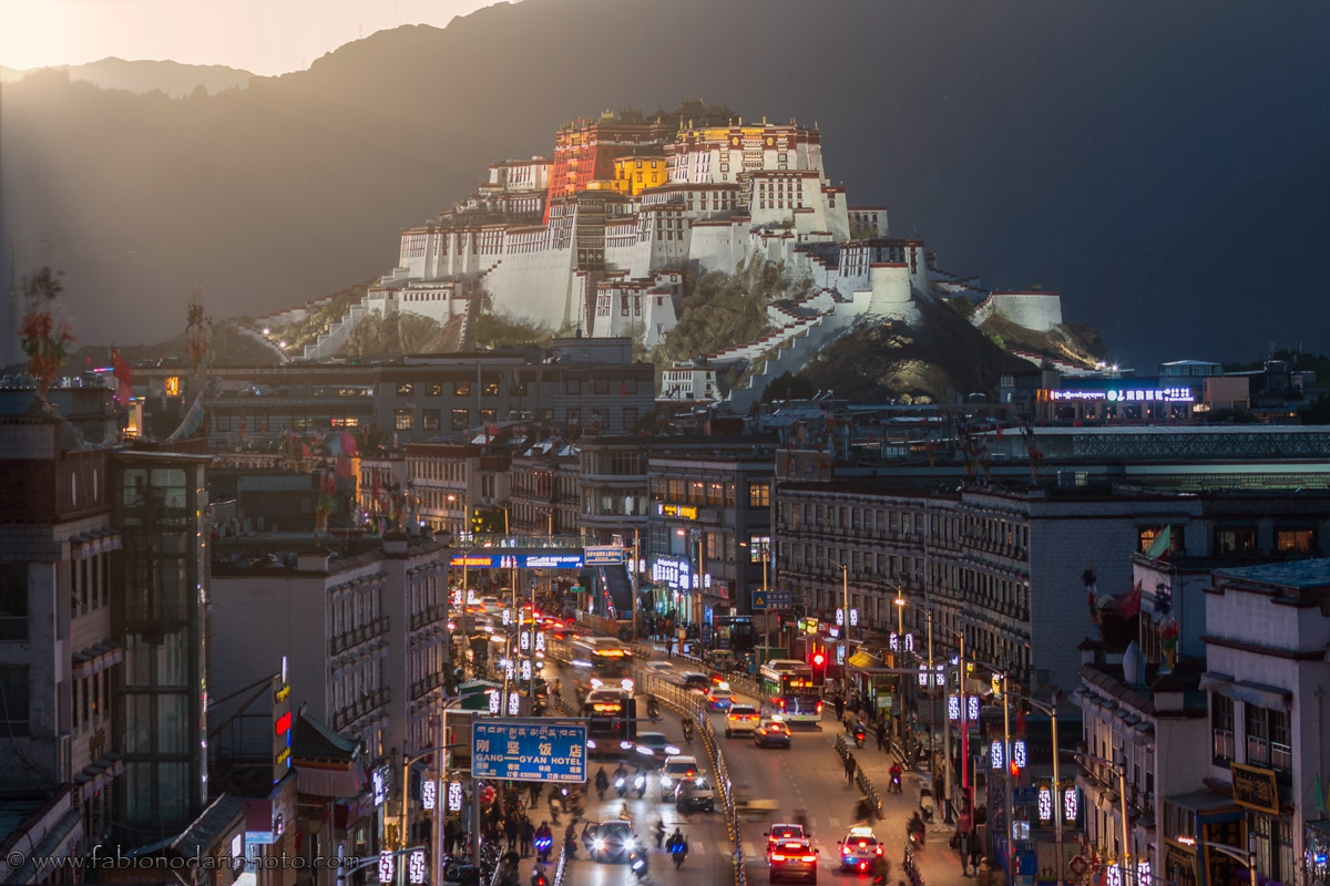
- Legendary spots like Everest Base Camp, Mount Kailash, and the Potala Palace.
- Deep-rooted Tibetan culture and dramatic Himalayan landscapes.
Cons
- Foreigners must join a tour and secure permits.
- Most places are not accessible to foreigners, even with a Travel Permit.
Best for: People who want to experience that “ultimate Tibet” experience. Here is my Tibet Travel Guide.
Qinghai

Pros
- Salt lakes, wild deserts, high-altitude monasteries.
- Very few tourists, relatively undiscovered.
Cons
- Numerous restrictions for foreigners.
- Long distances and rougher roads.
Best for: Road trippers, drone photographers, and fans of empty, alien-like landscapes.
Western Sichuan

Pros
- Massive monasteries (Litang, Tagong, etc), Tibetan towns, and mountain views. Deep Tibetan culture.
- Easily accessible from Chengdu.
Cons
- Some areas get crowded, especially along the increasingly popular Route 318.
- It’s becoming increasingly expensive.
Best for: Culture lovers and those who prefer fewer restrictions. Here’s my Western Sichuan travel guide.
If it’s your first time in this part of China, start with Western Sichuan. It’s deep, accessible, and photogenic. For something wilder, go for Qinghai. And when you’re ready for something more structured, Tibet is worth it (especially if you follow this itinerary), just know what you’re signing up for.
Final Thoughts

This isn’t your average road trip. It’s not cute cafes and curated photo spots. It’s wind, dust, cold mornings, silence, and landscapes that feel like they’ve never been touched. That’s what makes it special.
If you’re looking for a challenge, something raw and wildly beautiful, the road from Xining to Yushu is perfect for you. Take it slow, respect the altitude, and you’ll come back with a memory card full of alien landscapes and a mind full of new perspectives.
As always, don’t forget to get a VPN before coming to China. Alternatively, you can use an eSIM. If you need travel insurance, I recommend this one.
Here’s another interesting area to explore: the ancient Silk Road route in Gansu. Here you can find my Western Yunnan travel guide. Here are some more pictures I took during my trip.


Fabio, what a guide. Kekexili is something else entirely — driving through that emptiness with wild yaks and antelopes in the distance felt like being on another planet. And Yushu, watching pilgrims add stones to that sea of mantras… hard to put into words. Fourth trip together and every one has been completely different. Glad we got to do Qinghai with you.
Absolutely agree!
Hey there! Great article! Question: how many days would you recommend for a trip to Qinghai with a focus on nature and animal photography? Would 1 week to 10 days be decent?
Hi Pierre, given the distances I would recommend 10 days.
Hi Fabio, thanks for the amazingly informative post. Your photos are beautiful. I wonder if one can still appreciate the landscape in Qinghai at our eye level and not high above LOL if you know what I mean?
Hi Vanessa. Yes 100%, especially if you also enjoy taking pictures of the local people.